 |
 |


Knowledge of the formation and history of a lake is important to understanding its structure. The current chemical and biological condition of a lake depends on many factors, including:
- how it was formed
- size and shape of the lake basin
- size, topography, and chemistry of its watershed
- regional climate
- local biological communities
- activities of humans during the past century
There are three major areas in the US with abundant lakes:
- limestone sinkholes of Florida
- mountain lakes of the Pacific Northwest
- glaciated landscapes of the Great Lakes region
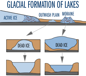
The focus of Water on the Web, and this Lake Ecology section, is on lakes in the glaciated landscapes of the Great Lakes region. In Minnesota, there are 12,034 lakes larger than 4 hectares (10 acres). The glaciers that covered much of the state until about 12,000 years ago created most Minnesota lakes. Glaciers formed lake basins by gouging holes in loose soil or soft bedrock, depositing material across stream beds, or leaving buried chunks of ice that later melted to leave lake basins (Figure 1). When these natural depressions or impoundments filled with water, they became lakes.

Figure 1
After the glaciers retreated, sediments accumulated in the deeper parts of the lake. These sediments entered the lakes from tributaries and from decomposed organic material derived from both the watershed and aquatic from plants and algae. An average Minnesota lake contains 9-12 meters of such sediment in its deeper parts.
Lake sediment deposits provide a record of a lake's history. Paleolimnology is the study of lake sediments. Paleolimnologists collect lake sediments using special coring devices to study a lake's physical, chemical and biological history. Lake sediments are often dated using the radioisotopes lead-210 and carbon-14. The age of a given sediment sample is based on the radioactive decay of the isotope. Other dating methods are based on identifying sharp increases of pollen in the core from ragweed and other plants indicative of agricultural soil disturbances or deforestation. Stratigraphic analyses of sediments have been used increasingly to assess the history of lakes, especially with regard to human impact. Lake acidity, water clarity, and algal productivity have been inferred by analyzing diatom abundance and composition, as well as plant pigments. Soil erosion can be inferred by the proportion of inorganic and organic matter and by chemical analyses for metals. Recently in Minnesota, these sediment dating, coring, and analysis techniques have been used to estimate spatial and temporal patterns in the mercury (Hg) content of lake sediments. These data were used to infer trends and sources of Hg in the state.