 |
 |
Stream Water Quality Monitoring Programs
A number of federal, state, regional and local governmental agencies monitors the quality of Minnesotas streams and rivers including the USGS, PCA, DNR, the Metropolitan Council Environmental Services (MCES), and certain local units of government. In addition, a number of citizen groups engages in monitoring activities. Each agency designs its monitoring program to meet its specific needs.
Federal Programs. The Water Resources Division of the U.S. Geological Survey (USGS) currently operates two nationwide stream water-quality monitoring networks, the Hydrologic Benchmark Network and the National Stream Accounting Network (NASQAN). Samples from stations in each program are sampled approximately four or five times during the year and analyzed for the parameters listed in Appendix C. A 20-year record of data exists for most sites. The USGS stores all water-quality data in their WATSTORE database available via STORET, the U.S. EPAs large water-quality database. Requests for small amounts of data from STORET (total costs under $25) may be obtained by contacting the EPA Region 5 Freedom of Information Officer. Data can also be obtained online or from the PCA. There are no fees for this service, except for unusually large data retrievals, and the wait time for most data requests is approximately two weeks. (Contacts for data requests are listed in Appendix B.)
The nationwide Hydrologic Benchmark Network Program provides information on baseline water quality conditions. The network consists of a set of stations located in small, pristine drainage basins. Because point source pollution is not a problem in these areas, this program has been especially useful in describing the effects of non-point atmospheric deposition of pollutants on streams. Only one Hydrologic Benchmark Network station is located in Minnesota on the Kawishiwi River near Ely. Another station, located on the North Fork of the Whitewater River, closed in 1993.
The National Stream Accounting Network (NASQAN) was established in 1973 to obtain information on the quality and quantity of water draining into the oceans, describe geographic variability in water quality, detect temporal trends, and provide a nationally consistent database. Most NASQAN stations are located at the mouths of rivers and tributaries. As a result, this programs stations are broadly representative of their basins, but they cannot provide specific, detailed data to characterize the basins. This has limited the ability of the program to analyze geographic patterns in water quality. In the early 1990s, this program experienced a significant reduction in size declining from ten NASQAN stations in Minnesota in 1993 to four in 1994. Existing stations are located on the Minnesota River at Jordan, the Mississippi River at Royalton and Nininger, and the St. Louis River at Scanlon. Figure 5.1 shows the locations of the NASQAN stations, the USGS Hydrological benchmark stations and other USGS water quality monitoring stations.
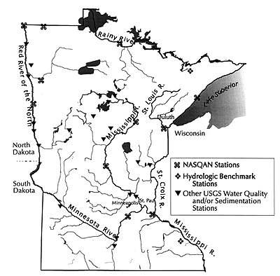
Figure 5.1 Locations of NASQAN, USGS Hydrological Benchmark and other water quality monitoring stations. U.S. Geological Survey, 1993.
To assess the quality of the nations surface and ground water, the National Water-Quality Assessment Program (NAQWA) began in 1991. The program was designed to describe the status and identify trends in water quality and identify natural and anthropogenic factors affecting water quality. The scope of the program is large, covering approximately 60 to 70% of the water used by the entire U.S. population. This information will provide water managers and policy makers with a better understanding of the geographic differences water quality and concomitant causes.
Two basins that lie partially within Minnesota are being studied as part of NAWQA: the Red River of the North Basin and the Mississippi Basin in the Minneapolis-St. Paul metropolitan area. The Red River of the North project began in 1991 and the Mississippi River project in 1994. Both projects were recently completed. USGS Water Resources Investigations Reports contain information summarizing the water quality of the basin. (See reports 3 and 4 in this series of WRC River reports for further information on these studies.)