 |
 |
KEY STREAM PROCESSES AND OTHER IMPORTANT SYSTEM CHARACTERISTICS
The observed structure in a particular stream corridor is a result of hydrologic, geomorphic and physical and chemical processes operating within the river corridor as well as the influence of biological functions and overall system equilibrium. This section examines how these processes and characteristics influence the structure of the stream corridor.
Hydrologic and Hydraulic Processes
The hydrologic cycle illustrates the cyclic transfer of water from precipitation through storage and runoff, to surface and ground water, and eventually back to the atmosphere through evaporation and transpiration, as shown in Figure 1.5 (Federal Interagency Stream Restoration Work Group, 1998). When precipitation reaches the earth it moves along one of three possible routes described by the hydrologic cycle. It evaporates/transpires back into the atmosphere, infiltrates the soil profile, or runs across the earths surface into a water body. These pathways influence how water moves in the stream corridor. The relationship between the amount of water that falls on the watershed and the water that flows in the river channel (discharge) is determined by three major factors: (1) the nature, timing, and location of the water input in the watershed, (2) water demands of the system interception, evaporation and evapotranspiration, and (3) flow pathways and water storage in the watershed. A dynamic interaction occurs between climatic variables, such as precipitation and temperature, and physical attributes, such as hydraulic gradient (slope or head) and watershed topography.
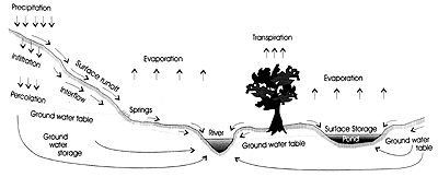
Figure 1.5 Hydrologic Cycle. Adapted from Adapted from Black, P. 1990. Watershed Hydrology. p. 267.
Water inputs to the river system come ultimately from precipitation rain or snow via overland and underground routes. The nature, timing and location of the water input influence the force of a rivers flow. For example, precipitation in the form of snowfall does not reach the river as runoff until it melts in the spring.
Water demands on the system due to interception, evaporation and transpiration also influence river flow. In the U.S., more than two-thirds of precipitation evaporates back into the atmosphere. Some precipitation is intercepted by vegetation and other surfaces and evaporates into the atmosphere from the interception sites. How quickly the water evaporates from the interception sites after a precipitation event depends on climatic conditions. Evapotranspiration describes the movement of water back into the atmosphere through the diffusion of water vapor from vegetation, known as transpiration, and through evaporation of moisture contained in the soil.
Precipitation that is not evaporated or intercepted succumbs to the law of gravity and becomes runoff. Gravity pulls the water down from the surface of leaves, along the stems of plants, over land, through soil pores and rock fractures, downhill as far as it will go to oceans and landlocked lakes. It may seep underground and flow for short distances to emerge, for example, as a spring, or it may remain beneath the earths surface for years or even millennia. The nature of the watersheds topography, soils and vegetation influences its capability to store water. Forested watersheds with active wetlands can store large quantities of water, slowing and damping the peak flood pulse and acting as a kind of flood control system.