 |
 |
LAND USE PATTERNS and ECOREGIONS
Various plant and animal species prefer different habitat conditions and therefore establish distinct communities in areas that provide preferred conditions. Prior to the influence of human activities, conditions in Minnesota favored establishment of mixed prairie and hardwood forests in the southwestern quarter of the state, grading through mixed pine and hardwood into pine forests in the northeast, with peat bogs developing in the northwest. Human activities, such as clearing of forests and draining of wetlands for agriculture, have altered the native landscape significantly. Current land use patterns in the state are shown in Table 2.1. Land uses range from dense managed forests in the northeast to heavily tilled cropland in western and southern parts of the state. In the central portion of the state there is a mixture of land uses, including cropland, woodland and prairie.
| Description | Acreage | Percent |
| Cultivated land | 22,694,200 | 42.0 |
| Forested | 14,434,482 | 26.7 |
| Bog/marsh/fen | 5,728,056 | 10.6 |
| Hay/pasture/grass land | 4,977451 | 9.2 |
| Water | 3,211,643 | 5.9 |
| Urban and rural development | 1,472,267 | 2.7 |
| Brushland | 1,326,796 | 2.5 |
| Mining | 147,175 | 0.3 |
| State Total | 53,992,070 | 100.0 |
Table 2.1 Land Use in Minnesota. Land Management Information Center (1999), St. Paul, MN.
Climate, topography, and land-use patterns, along with soil and water conditions, form habitat for plants and animals. Large areas that contain similar communities of plants and animals are called ecoregions. Ecoregions are determined based on mapped information on land use, soil types, land surface form, and potential natural vegetation. Streams draining watersheds within the same ecoregion are believed to exhibit similar characteristics, such as physical habitat, hydrology, water chemistry, and biotic communities. According to the classification system for ecoregions developed by the U.S. Environmental Protection Agency, seven ecoregions are found in Minnesota: Red River Valley, Northern Minnesota Wetlands, Northern Lakes and Forests, North Central Hardwood Forests, Northern Glacial Plains, Western Corn Belt and Driftless Area. Land uses, topography, soil types and other information for each of the seven ecoregions are described in Figure 2.6.
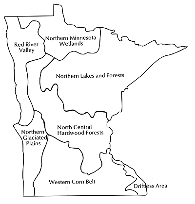
| NORTHERN MINNESOTA WETLANDS — Flat. Soils dominated by organic peats. Very low population density. Land use divided between forest lands (~50%), marsh and water bodies (~30%) and agriculture (<20%). |
| NORTHERN LAKES AND FORESTS — Gentle4 slopes with hilly areas. Soils dominated by sand and silt. Generally low populatino density with some density populated urban areas. Predominately forest lands with some agricultre, mining and urban development. |
| NORTH CENTRAL HARDWOOD FORESTS — Irregular topography with plains and rolling hills. Soils dominated by sand and slit. Population density relatively low in northwestern area and very high in southeastern portion. Mixed land use with forests in the northwest and agricultural and urban areas in the southeast. |
| DRIFTLESS AREA — Hilly area with some steep slopes. Predominately shall silty soils. Population density reltively high. Land use mixed (36% forest, 40% agriculture and 14% pasture or open land). |
| WESTERN CORN BELT — Flat. Silty soils that easily erode. Population density relatively high. Predominately cropland (more than 80% doybeans and corn). |
| NORTHERN GLACIATED PLAINS — Flat. silty soils. Low population density. Agricultural land use dominates with more then 83% of land under corn and soybean. |
| RED RIVER VALLEY — Relatively flat. Fine and clay soils dominate. Low population density. Heavilty cultivated in small grain. Cultivation of marginal land and removal of shelter belts leading to increased in suspended sedminent (turbidity). |
Figure 2.6 Minnesotas Seven Ecoregions