 |
 |

![]()
- Why are lakes so variable?
- What are ecoregions and how do they influence lakes?
- Why are lakes in northern Minnesota different from those in southern Minnesota?
- How did my lake form?
- How does knowing about ecoregions help us manage lakes?
- Who can I contact if I have questions or a problem related to ecoregions?
- What are some additional resources related to ecoregions?
Why are lakes so variable?
There are a variety of reasons why lakes are so variable. Some of the most important include the lake’s size and shape, what activities occur in the lands that drain into it (watershed), what ecoregion the lake is located in, and when and how the lake basin was formed. These factors, acting in various combinations, have created the multitude of lake types found in Minnesota today.
What are ecoregions and how do they influence lakes?
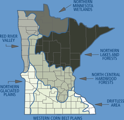
Minnesota lies at a crossroads of ecological land types, with widespread differences in soils, underlying geology, and plant and animal communities. These differences are identified and classified into ecoregions, or broad areas in Minnesota that share similar land uses, soils, land and surface form (topography), and potential natural vegetation. Minnesota is classified into seven ecoregions. Ninety-eight percent of Minnesota’s lakes occur in just four of them: Northern Lakes and Forests, North Central Hardwood Forests, Western Corn Belt Plains, and Northern Glaciated Plains. The other three ecoregions, Northern Minnesota Wetlands, the Red River Valley, and the Driftless Area, contain few lakes, but are rich in streams.
Lakes and rivers within ecoregions, because they occur in an area of similar land type, often have similar physical characteristics, water chemistry, and biological communities. It is often said that, “A lake is a reflection of its watershed,” and therefore of its ecoregion. In other words, what happens on the land and the basic characteristics of the land (soil, geology, vegetation, drainage, etc.) affects the quality and health of a lake or stream. The number, appearance, and condition of lakes vary among ecoregions because of glacial history, geology, soil type, land use, and climate. Typical values for chemical and physical measurements have been compiled for the four lake-rich ecoregions by evaluating information from minimally impacted lakes and rivers. These values provide a “yardstick” for comparing other lakes and rivers in the same ecoregion.
Why are lakes in northern Minnesota different from those in southern Minnesota?
If you’ve visited lakes across Minnesota, you probably recognize that the northern lakes are often fairly small and relatively deep compared to the large, shallow lakes common in southern Minnesota. These differences can be understood by observing that these lakes occur in two different ecoregions. Soils in the Northern Lakes and Forests ecoregion tend to be lower in nutrients than soils in the Northern Corn Belt Plains ecoregion, causing the northern lakes to be less productive.
In addition, the size and depth of a lake influence characteristics such as water clarity and acidity. Lakes that are deep relative to their size, such as those in northern Minnesota, tend to be clearer with less nutrient-rich water. In contrast, lakes that are shallow relative to their size, such as those in southern Minnesota, tend to be more eutrophic (enriched with nutrients, resulting in more algae and greater plant growth). Common land use practices also differ as one moves from southern to northern Minnesota.
Ecoregion differences also influence a lake’s sensitivity to human impacts. For example, watersheds in northern Minnesota are often rocky, with thin soils that have a minimal capacity to buffer acidic input from the atmosphere. Watersheds to the south have deeper soil, better able to buffer acidic inputs, but with more potential to cause impacts to lakes from sediments and turbidity.
How did my lake form?
Although it is known as the “Land of 10,000 Lakes,” Minnesota actually boasts over 11,842 lakes at least 10 acres in size. Our lakes are mostly the result of glaciers that passed over the state, leaving behind rocky ridges of till, gouging out depressions, and depositing thick plains of sandy outwash. When the glaciers melted about 10,000 years ago, blocks of ice buried in the till began to melt, leaving small, deep lakes. The melting ice created rivers that carried large volumes of water and sediment. These rivers and their sediment loads filled depressions and dammed smaller streams to create lakes. Some lakes have been created by human activity, such as the reservoirs on the Mississippi or along the border with Canada. Other, more temporary, lakes have been constructed by beavers.
Since the glaciers departed, Minnesota’s lakes have been gradually filling in with sediment and organic material as plants die and settle to the bottom. Unfortunately, humans have dramatically accelerated the aging process by adding nutrients and increasing sedimentation due to land use practices, creating eutrophic (enriched) lakes that experience algae blooms and excessive plant growth.
How does knowing about ecoregions help us manage lakes?
Typical values for chemical and physical parameters have been compiled for the seven ecoregions by monitoring unimpacted water bodies (lakes or streams with minimal human disturbance). These values help us identify what conditions might have existed before human settlement and help us develop realistic expectations for how lakes or streams might be restored to a more “natural” state. It is unrealistic to expect a shallow, southern Minnesota lake to have the same water clarity or productivity, for example, as a northern Minnesota lake. Ecoregions help us understand these differences.
Who can I contact if I have questions or a problem related to ecoregions?
Check your local telephone listing, the “Who to Contact” section of the Minnesota Shoreland Management Resource Guide Web site, www.shorelandmanagement.org, or the Web sites listed below for:
- Minnesota Pollution Control Agency (MPCA) (www.pca.state.mn.us)
- Minnesota Department of Natural Resources (MDNR) (www.dnr.state.mn.us)
- U.S. Environmental Protection Agency (EPA) (www.epa.gov/ceisweb1/ceishome/atlas/nationalatlas/ecoregions.htm)
What are some additional resources related to ecoregions?
- A Primer on Limnology. 1992. B.A. Monson.
- Minnesota’s Natural Heritage: An Ecological Perspective. 1995. J.R. Tester.
- Minnesota Lake and Watershed Data Collection Manual. 1994. Minnesota Pollution Control Agency.
- A Citizen’s Guide to Lake Protection. 1985. Minnesota Pollution Control Agency and Freshwater Foundation.
- A Guidebook for Lake Associations. 1997. Minnesota Lakes Association and The Center for Urban and Regional Affairs.


![]()