 |
 |
CLASSIFYING RIVERS FOR BETTER MANAGEMENT
![]()
- Why are streams classified?
- How are streams classified?
- What is the connection between rivers and watersheds?
- How do streams form meanders?
- Why do stream banks erode?
- What is a hydrograph and how do human activities change the hydrograph?
- Who owns and manages rivers and streams in Minnesota?
- What are some additional resources related to river classification?
- Who can I contact if I have questions or a problem related to river classification?
Why are streams classified?
Streams are classified to help identify similarities and differences among streams, to assess ecosystem health, and to help establish policies and regulations. By grouping similar streams into categories, resource managers can make better choices about how to protect or restore them. Streams may be classified based on channel dimensions, hydrology, or the ways humans use them (e.g., navigation, recreation, development, irrigation, and water supply). For example, there are more stringent water quality standards for rivers and streams that are classified for use as a water supply than for rivers that are classified for navigation.
How are streams classified?
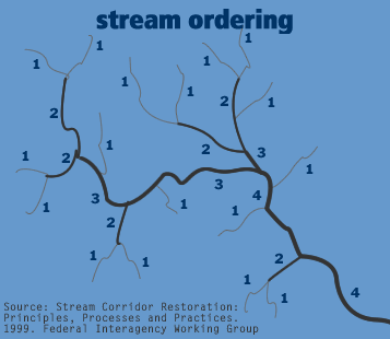
There are several classification schemes that can be used. Which one is “right” depends on what the resource manager is trying to accomplish. “Stream order” is one way to classify streams. The stream order classification looks like branches on a tree. The initial channel where a small stream first appears is referred to as a first order stream. When two first order streams come together, they form a second order stream. With each successive downstream junction, stream order increases. As stream order increases, other characteristics change, such as channel shape, drainage area, habitat, and biological communities.
Another method of stream classification is the Rosgen system. Rosgen’s eight basic stream types are based on a general description of the following characteristics: geomorphological characterization (e.g., landform, soils, climate), morphological description (e.g., channel pattern, width-to-depth ratio, sinuosity, slope), stream condition (e.g., vegetation, flow, stability), verification (e.g., sediment transport, fish biomass), and the size and shape of the stream channel. For example, streams in steep terrain tend to follow a fairly straight path and to have more characteristics in common with one another than they do with low-gradient, curvy streams. Knowing the stream type makes it easier for a resource manager to predict the outcome of a certain practice, because similar rivers and streams tend to respond to changes in similar and predictable ways. The Rosgen method is commonly used for developing management plans.
What is the connection between rivers and watersheds?
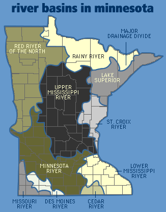
A watershed is the drainage basin or area from which surface water drains toward a lake, stream, or wetland. Water in most streams and rivers originates primarily from surface runoff on upland areas. Minnesota has eighty-one primary watersheds within eight major river basins. For more information on watersheds, see the Quick and Easy Answer Fact Sheet “Everybody Lives in a Watershed.”
Why do stream banks erode?
Stream banks erode because the force of moving water (stream energy) lifts and carries the silt, sand, gravel, and rocks downstream. Banks also erode as groundwater seeps through the bank, loosening the soil. Changes in water flow in the stream (e.g., flooding or drain tiling) or removal of vegetation from the bank may increase erosion. For more information on erosion see the Quick and Easy Answer Fact Sheet “Minimizing Shoreland Erosion.”
What is a hydrograph and how do human activities change the hydrograph?
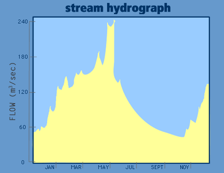
A hydrograph is a graphical representation of the volume of water flowing past a particular point in a stream over time. A hydrograph illustrates changes in streamflow due to rainfall, snowmelt, drought, or water withdrawal. Human activities and land use can significantly alter the natural patterns of stream flow. Increasing impervious surfaces in the watershed, clearcutting forests, drain-tiling agricultural fields, filling or draining wetlands, diverting stormwater, and channelizing streams can increase both the volume of flow and the speed with which runoff reaches a stream. Diversion, irrigation, or other withdrawals can also change stream flow, reducing baseflow and changing the characteristics of the river.
Who owns and manages rivers and streams in Minnesota?
Like all public waters in Minnesota, streams and rivers are owned by all Minnesotans. State laws and local rules and ordinances regulate rivers and floodplains. Various aspects of Minnesota’s rivers are managed by agencies at federal, regional, state, and local levels, including the U.S. Army Corps of Engineers, U.S. Environmental Protection Agency, Minnesota Department of Natural Resources (MDNR), Minnesota Pollution Control Agency (MPCA), Metropolitan Council, watershed districts, and watershed management organizations. The Minnesota Environmental Quality Board (EQB) sets policies for rivers and streams in Minnesota. Federal agencies administer the sections of the Clean Water Act addressing point source discharges to the stream and alteration of the streambed by removal or dredging of materials below the Ordinary High Water Level (OHW). The MDNR regulates withdrawals from rivers and changes to the streambank above the OHW. The MPCA sets water use standards and provides permits for discharges to streams. Counties and other local units of government regulate land uses adjacent to the stream and on the floodplain.
Although you may technically “own” land adjacent to a stream, you must comply with the regulations that are written to protect water quality and quantity for everyone. Water withdrawn for uses such as public supply, irrigation, and industrial needs requires a permit. Regulations also exist for dams, impoundments, commercial fishing, and waste disposal.
Who can I contact if I have questions or a problem related to river classification?
Check your local telephone listing, the “Who to Contact” section of the Minnesota Shoreland Management Resource Guide Web site, www.shorelandmanagement.org, or the Web sites listed below for:
- Rivers Council of Minnesota (RCM) (www.riversmn.org)
- Minnesota Pollution Control Agency (MPCA) (www.pca.state.mn.us)
- Minnesota Department of Natural Resources (MDNR) (www.dnr.state.mn.us)
- Mississippi Headwaters Board (MHB) (www.mhbriverwatch.dst.mn.us)
- Minnesota River Basin Data Center (mrbdc.mnsu.edu)
- Metropolitan Council (www.metrocouncil.org/environment/RiversLakes)
What are some additional resources related to river classification?
- Minnesota Rivers: A Primer. 1999. M.E. Renwick and S. Eden. University of Minnesota Water Resources Center
- Streambank Erosion… Gaining a Greater Understanding. 1991. D. Luethe and C. Bentley, Minnesota Department of Natural Resources Division of Waters
- Stream Corridor Restoration Manual: Principles, Processes and Practices. 1999. Federal Interagency Stream Corridor Restoration Working Group


